
They produce ArcGIS system software
ArcGIS is a geographic information system for working with maps and geographic information maintained by the Environmental Systems Research Institute. It is used for creating and using maps, compiling geographic data, analyzing mapped information, sharing and discovering geographic information, using maps and geographic information in a range of applications, and managing geographic information in a database.

ArcGIS Online
ArcGIS Online is a complete cloud-based mapping platform that allows you to create and share maps and apps with anyone. ArcGIS Online is a scalable and secure software-as-a-service (SaaS) that features ready-to-use maps, data, and apps. You can deploy solutions and be productive right away, on whatever device you use—desktops, browsers, smartphones, or tablets.
ArcGIS Online delivers a complete distributed GIS in the cloud
Because ArcGIS Online is hosted by Esri, you do not have to manage any infrastructure or hardware. Instead, when you create content with an ArcGIS app, you can publish that content to ArcGIS Online and make it immediately available to other users. ArcGIS Online automatically scales to meet peak periods of demand. In this way, ArcGIS Online lets you share location-based insights throughout your organization, helping your staff improve the way they work and make better decisions.
ArcGIS Desktop
ArcGIS Desktop is a complete software suite for desktop GIS. With ArcGIS Desktop, you get powerful desktop applications that you can use to create maps, perform spatial analysis, and manage geographic data and imagery. In addition, you can access the entire ArcGIS platform, allowing you to publish geographic content and share it with others.
ArcGIS Desktop includes:
- ArcGIS Pro.
- ArcGIS map.
ArcGIS Pro
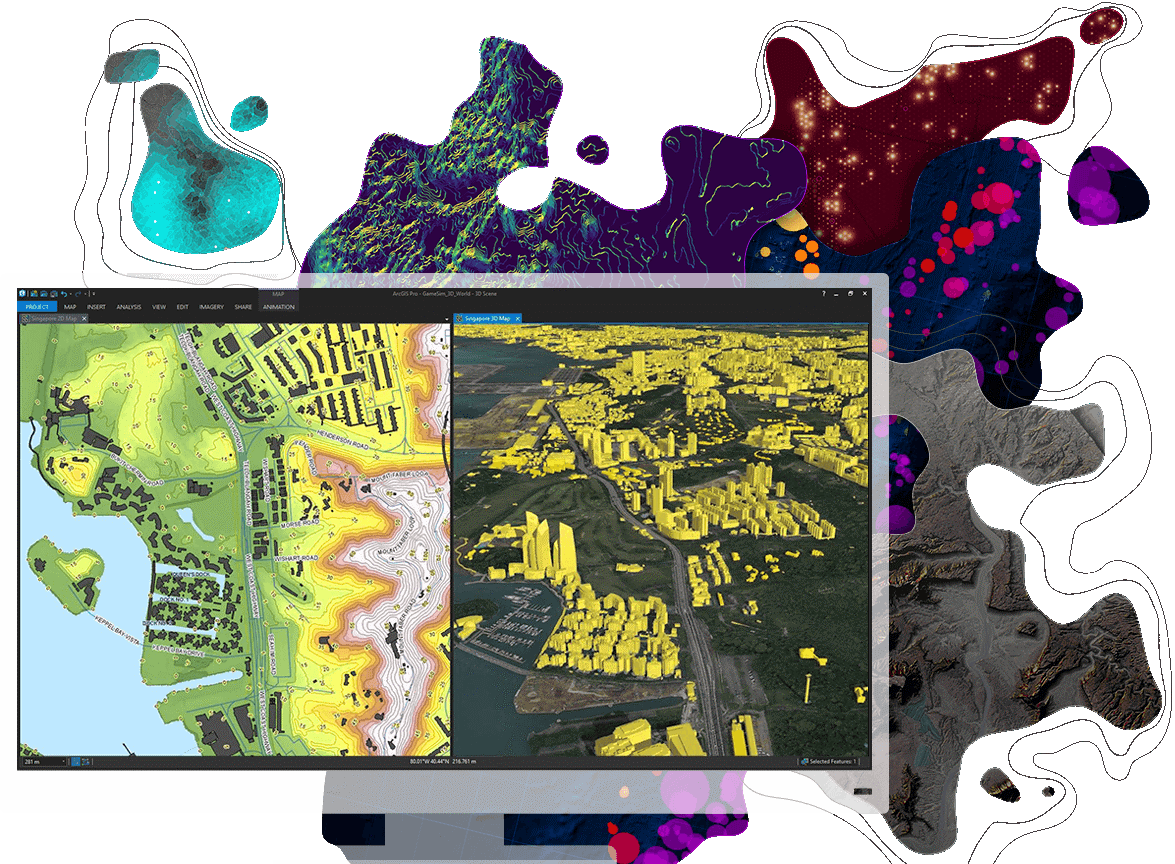
ArcGIS Pro is Esri’s powerful, single desktop GIS application. Technologically ahead of everything else on the market, ArcGIS Pro supports data visualization, advanced analysis and authoritative data maintenance in both 2D and 3D. ArcGIS Pro is tightly coupled with the ArcGIS platform supporting data sharing across ArcGIS Online a nd ArcGIS Enterprise through Web GIS
1. Transform data into maps and actionable information
Mash up multiple data sources to make maps that are as smart as they are beautiful. Use powerful 2D and 3D analytical tools to identify patterns and trends. Then put this information to good use by sharing it within your organization, online, and through mobile apps.
2. Cartography and visualization
Work with intuitive and intelligent cartography tools at any map scale to create amazing 2D and 3D maps for print, apps, dashboards, and the web
3. Integrate data from multiple sources
Combine data from various sources and formats. ArcGIS Pro supports industry and community standards to ensure inclusion of any dataset you have.
4. Visualize your data
Display data in 2D and 3D simultaneously. Manage multiple maps and layouts in a single project-based workflow.
5. Edit and analyze your data
Simplify data editing and analysis with context-sensitive tools. Perform interactive 2D and 3D analysis. Automate work with ModelBuilder or Python.
ArcGISMap
ArcMap is the industry-leading 32-bit desktop GIS application. With ArcMap, you can access a rich collection of tools that let you visualise, analyse, manage, and publish spatial data and imagery. These tools help you transform your data into useful maps that support staff across your organisation
ArcGIS Enterprice
ArcGIS Enterprise provides a complete GIS that lets you access powerful mapping and analytics and manage location-enabled data, all from a web browser. You can run ArcGIS Enterprise anywhere, behind your firewall, in the cloud, or in an Esri-managed environment. No matter how you deploy it, ArcGIS Enterprise helps you deliver GIS capabilities to every app, user, and device in your organisation so you can improve workflows, analysis, and decision making.
ArcGIS Enterprise provides everything you need to deploy a distributed GIS including:
An Enterprise GIS portal
ArcGIS Enterprise includes a secure portal website where you can organise your geospatial assets and share them with other people in your organisation. The portal is designed to be a highly collaborative environment that lets anyone easily create maps, work with apps, and perform analytics. You can control access permissions for content and capabilities through unique identities for each user.
Apps for everyone
ArcGIS Enterprise provides configurable apps designed to make your organisation more effective and efficient. These apps include dashboards that summarise operational information, interactive maps embedded in enterprise systems, mobile apps for field data collection, apps for connecting with the public, and more.
Spatial analytics
With ArcGIS Enterprise, you can use spatial analysis to better understand your operational landscape and determine what actions to take. ArcGIS Enterprise provides analytic tools that help you assess the characteristics of places, uncover spatial relationships, find the best locations and routes, detect and quantify patterns and hot spots, and model predictions.
Ready-to-use maps
ArcGIS Enterprise gives you access to the ArcGIS Living Atlas of the World, a curated collection of basemaps, imagery, and authoritative maps and data on thousands of topics. You can browse the content included with the Living Atlas and incorporate it in your work.
A powerful GIS server
ArcGIS Enterprise provides a GIS server that lets you publish services for your GIS work. These services allow you to share maps, data, and analytic tools over the web, so users can access them through a variety of apps and devices. You can add more GIS servers as needed to distribute and balance the workload.
The Enterprise geodatabase
ArcGIS Enterprise provides a robust geodata storage and management framework called the geodatabase. You can use the geodatabase to enable multiuser data editing, enforce rules and relationships in your data, and manage metadata. These capabilities help you improve data integrity and maintain a complete, authoritative system of record.
ArcGIS Enterprise also offers more advanced capabilities through specialised servers that unlock additional functionality. These specialised servers allow you to:
– Analyse massive volumes of data
– Process large imagery collections
– Monitor events in real time
ArcGIS Enterprise allows you to organise, manage, analyse, and share your enterprise content while maintaining complete control over data security and access. You can use ArcGIS Enterprise to provide a scalable, distributed GIS that supports everyone in your organisation. This lets you deliver location-based content and capabilities that help you improve your workflows and make more effective decisions.
ArcGIS for Developers
ArcGIS is a mapping platform for developers who want to build geospatial apps that support the specific needs of their users. With ArcGIS, you can develop web, mobile, and desktop apps that incorporate mapping, visualisation, analysis, and more. Apps you create using ArcGIS developer tools can also connect to Esri’s cloud services, letting you access a wide range of ready-to-use content and location services.
ArcGIS Apps
Esri offers ready-to-use apps that let you analyse information, make decisions, monitor your operations, gather and edit data in the field, engage your community, and share information with anyone who needs it. You can access these apps over the web, on mobile devices, or in your business systems, letting you work with your maps, data, and analytic tools no matter where you are.